At present, there are different models of portable GPS handsets on the domestic and foreign markets, such as Magellan-315 handheld GPS receivers, Gamin handheld receivers, and SP24-type CPS handheld receivers produced in France. "GPS handsets" are bothersome when measuring farmland plots. They only use digital display of measured area values, and they do not have graphical display of plot shapes. They are inconvenient to use and operate only in English. This is inconvenient for Chinese farmers. Friends are a defect. For the current high-end GPS field area measurement instrument (such as the use of ARM chip), although the function is more, but the price is quite high, and the use of complex.
This topic summarizes the research results of Geng Zhengjun and Yang Shuming et al. on the measurement of GPS farmland area. It plans to use the GPS positioning function to develop multi-functions using low-cost GPS modules, SPCE061A single-chip data acquisition modules, keyboards, and LCD liquid crystal displays. The farmland area measuring instrument can realize fast GPS measurement of the land area of ​​farmland of arbitrary shape, and real-time display the position, figure, area of ​​the measured land, the earth coordinate of any point, and the distance between any two points. In addition it also has a compass, temperature and humidity detection, scientific calculators and other functions. The multi-purpose GPS farmland area tester will be a portable tool for farmer friends, farm machinery operators and scientific and technical personnel to test the land area of ​​farmland.
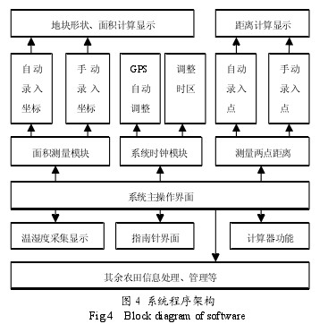
System software functions The system program design can be divided into three levels, namely: the main interface level, function module level, sub-function level. The six main functions are made into six main program modules for main program calls, and their respective sub-functions are integrated within the module program, as shown in Figure 4. In order to facilitate the programming of the whole program, the 89C52 program design as an interface chip is completely complied with an interface chip communication protocol, temperature sensor reading, keyboard scanning, and GPS data reading and extraction are integrated in the 89C52. It uploads data to the SPCE061A microcontroller through an interrupt request, thus preventing program flow from becoming confusing. For measuring each point of the polygon, if the selected GPS coordinate is automatically entered, the measuring instrument will receive the GPS coordinates of the point 6 times at this point and then take the average value. The point is automatically deleted by the point system with a large error. Therefore, when measuring each point, it is necessary to wait until the measuring instrument prompts to receive the coordinate before moving to the next point measurement. If you choose to manually enter GPS coordinates, each coordinate value received by each point will be displayed on the system interface, waiting for the user to determine whether the value is valid, and in this mode you can enter known coordinate points or delete. A point is calculated.

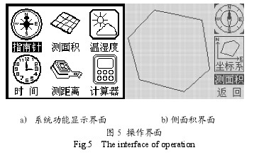
Fig. 4 System Program Architecture The system's main interface is the first operation interface that appears after power on. The main function selects and calls the six function modules and belongs to the main interface level. After entering the main operation interface, use the keyboard to select the function module to be used. The operation effect of the host operation interface is shown in Figure 5. a) The figure shows the system function display interface. b) The figure shows the interface when browsing to the measurement area option. You can press the OK key to enter the measurement area interface.

Figure 5 Operational Interface Measurement Instrument Performance Test
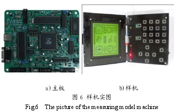
The prototype of the multifunctional farm area measuring instrument and its main board are shown in Figure 6. In order to verify the accuracy of the area test device, an area measurement was performed and the system error was obtained. The temperature and humidity sensor is a digital sensor that contains calibration internally and does not require verification of its accuracy.

Figure 6 Prototype real map test site is taken as the South Campus of Henan Science and Technology University. Field measurement was conducted using an area measuring instrument playground and the actual area of ​​the playground was measured using a tape measure. The length of the playground was 189.3 m and the width was 93.4 m.
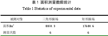
Compare the two to get the error of the area test device. Along the rectangle formed by the iron fence of the playground, first discard the point in the southeast direction and collect the three vertices of the playground rectangle to measure the area. The plot is a right-angled triangle. The area of ​​the triangle is half of the original playground area, and then the entire playground rectangle is measured. area. The above tests were conducted six times in total. The test adopts the method of averaging to reduce the test error and verify the performance of the measuring instrument. The data analysis is shown in Table 1.
Table 1 shows that these two area measurement errors are less than 1%, and as the measurement area increases, the error will be further reduced.


Table 1 Area measurement data statistics The measuring instrument can carry out the positioning of farmland, the length and area of ​​the land, the display of the shape of the field, and the function of obtaining the temperature and humidity parameters and mathematical calculator of the land. This not only satisfies the basic measurement of farmland area by the market and farmers, but also satisfies the basic requirements of the harvesting area for precision agricultural combine harvesters. The measuring instrument is stable in performance, fast in operation, and has small measurement error in various parameters such as area. Meet the general farmland measurement accuracy requirements. At the same time, the successful design of the instrument also validates the correctness and rationality of the two-chip microcomputer combination program. Measuring instruments are easy to use, fast, easy to use and all-weather, will be welcomed by users and the market, but also lay the foundation for further intelligent integrated monitoring of the performance of precision agricultural combine harvesters, and take a road of precision agriculture that suits China's national conditions.
Automation Production Line,Automated Truss Equipment,Fully Automation Production Line,Automation Articulated Production Line
Ningbo Yien Machinery Co., Ltd , https://www.yiencnc.com
